We all latch a picture of a perpetual blazing desert to the name Death Valley, a name that strikes fear and desolation in everyone’s consciousness. It is a name that echoes dauntlessness, audacity, bravura and an intense adventure for those who dare. It is after all, the hottest national park in America. In July 10, 1913, Greenland Ranch in Death Valley hit 134°F (56.7°) and broke (Libya) El Azizia’s 90-year record of highest temperature, making Death Valley’s recorded temperature the highest in the world.
Death Valley does not fit in our regular definition of fancy. It is nothing but. However, this national park that nestles between California and Nevada is the national park of superlatives. Not only it is hottest national park in America with average high temperatures ranging from 110°F to over 120°F (43°C to over 49°C), but Death Valley is also the lowest and the driest. The Badwater Basin, the park’s lowest spot, rests at 282 feet/86 meters below sea level, with a vertical drop from the peak of the highest mountain in the park (Telescope Peak) to Badwater Basin that is twice the depth of the Grand Canyon. Its average rainfall is only 2 inches/5 cm per year.
Death Valley National Park, established on October 31, 1994, is also the largest national park in the lower 48 states. The largest national park outside of Alaska, Death Valley boasts 3.3 million acres /1.34 million hectares according to the National Park Service.
The park earned its name in 1849 when “emigrants bound for California’s gold fields strayed into the 120-mile long basin, enduring a two-month ordeal of “hunger and thirst and an awful silence.” One of the last to leave looked down from a mountain at the narrow valley and said, “Good-bye, Death Valley.”
Despite the park’s haunting name, Death Valley is alive with over 1,000 types of plants (including 50 that are found nowhere else in the world), 300 species of birds, 51 species of mammals (including bighorn sheep and mountain lions), 36 species of reptiles and a handful of amphibian and fish species. We witnessed Death Valley’s life ourselves when two wild coyotes were roaming just inches outside our parked car at Panamint Valley Road! Excavations also found evidence of human presence that dates back at least 9,000 years. It has also been inhabited by Timbisha Shoshone Native Americans for the past 1,000 years. In the recent years, gold prospectors including slaves, Chinese immigrants mining for silver and borax, Basque immigrants, and Japanese-Americans temporarily interned here during World War II, have made Death Valley their home.
In 2014, Death Valley’s annual visitation soared past its 1 million mark. Its non-conformity to the definition of beauty is exactly what attracts visitors every year. The hottest, the lowest, the driest, and the biggest – the superlatives that enthralls visitors like my husband and I to go and awe at such unparalleled beauty that is Death Valley.
As we drove out of Death Valley and its mysterious landscape slowly faded into our background, an astounding sunset came into display. It was one of the most unforgettable and remarkably one of the most breathtaking sunsets we have witnessed. It was indeed a marvelous conclusion to our month-long and amazing cross-country road trip. From one end of the North America continent to the other, we are finally heading to our last destination – to California, our new home.
P.S. Visit Death Valley National Park in winter, unless you truly want to experience the real Death Valley inferno in summer. ;)
Enjoying our lunch at a Filipino restaurant in Las Vegas before driving to California via Death Valley.Driving out of Las Vegas via Blue Diamond Road on Nevada Highway 160 West as we were heading to our new home, California.Cruising through Nevada and California via Bell Vista Road as we see a glimpse of Death Valley in the distance.Cruising through Nevada and California via Bell Vista Road as we see a glimpse of Death Valley in the distance. Ash Meadows National Wildlife Refuge parallels to our rightCruising through Nevada and California via Bell Vista Road as we approach Death Valley National Park.The Amargosa Opera House and Hotel at Death Valley Junction.The Amargosa Opera House and Hotel at Death Valley Junction. The town of Amargosa was booming due to the Borax mining business. The town is presently called Death Valley Junction.One of our first glimpses of Death Valley National Park.Cruising through Death Valley National Park, the biggest national park in the lower 48 states of America.Death Valley National Park is the hottest, the lowest and the driest national park in America.
OFFICIALLY INSIDE DEATH VALLEY NATIONAL PARK!
Officially inside the Death Valley National Park, Homeland of the Timbisha Shoshone.
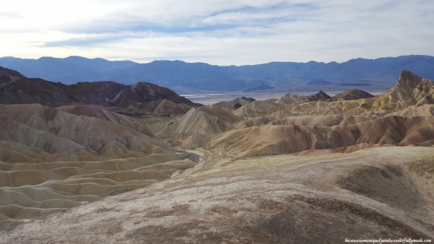
ZABRISKIE POINT
Zabriskie Point is a part of Amargosa Range located east of Death Valley in Death Valley National Park in California, United States.The Red Cathedral at Zabriskie Point in Death Valley National Park in California.Zabriskie Point is composed of sediments from Furnace Creek Lake, which dried up 5 million years ago – long before Death Valley came into existence.The Zabriskie Point in Death Valley National Park in California, was named after Christian Brevoort Zabriskie, Vice-President and General Manager of the Pacific Coast Borax Company in the early 20th century.The landscape surrounding Zabriskie Point at Death Valley National Park was formed by sediment from a dried-up lake.The landscape surrounding Zabriskie Point at Death Valley Natinal Park was formed by sediment from a dried-up lake.The landscape surrounding Zabriskie Point at Death Valley Natinal Park was formed by sediment from a dried-up lake.This location of Zabriskie Point at Death Valley National Park is featured prominently on the cover of U2’s album The Joshua Tree. Manly Beacon is seen on the right.Overlooking the basin of Death Valley National Park from Zabriskie Point.Overlooking the basin of Death Valley National Park from Zabriskie Point.Manly Beacon as see on the left, was was named in honor of William L. Manly, who along with John Rogers, guided members of the ill-fated Forty-niners out of Death Valley during the gold rush of 1849.A close-up of the Red Cathedral at Zabriskie Point in Death Valley National Park in California.Zabriskie Point in Death Valley National Park in California.Zabriskie Point in Death Valley National Park in California.Possibly overlooking the Furnace Creek from Zabriskie Point in Death Valley National Park.Zabriskie Point is a part of Amargosa Range located east of Death Valley in Death Valley National Park in California, United States.Zabriskie Point is a part of Amargosa Range located east of Death Valley in Death Valley National Park in California, United States.
FURNACE CREEK
Passing by The Inn at Death Valley.Approaching Furnace Creek in Death Valley National Park in California.The Furnace Creek Visitor Center is at Furnace Creek resort area on State Route 190 in Death Valley National Park in California.Outside the Furnace Creek Visitor Center in Death Valley National Park in California, standing at 190 feet (58 m) below sea level.
MESQUITE FLAT DUNES
The Mesquite Flat Sand Dunes is located in central Death Valley near Stovepipe Wells. It is easily accessible from California Highway 190.The Mesquite Flat Sand Dunes of Death Valley has been used for several movies including the Star Wars series.The mesmerizing Mesquite Flat Sand Dunes of Death Valley National Park in California.The equally astounding surrounding of Mesquite Flat Sand Dunes of Death Valley National Park in California.The equally astounding surrounding of Mesquite Flat Sand Dunes of Death Valley National Park in California.
LEAVING DEATH VALLEY
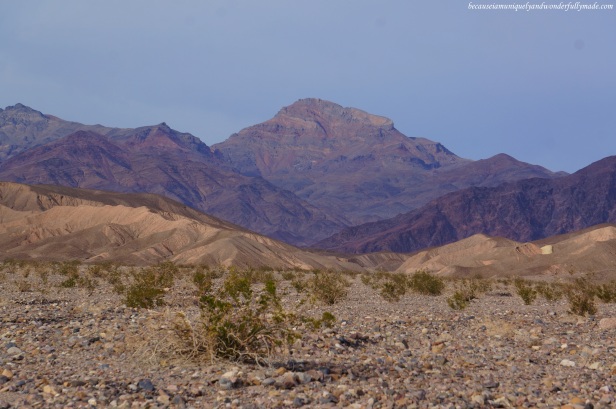
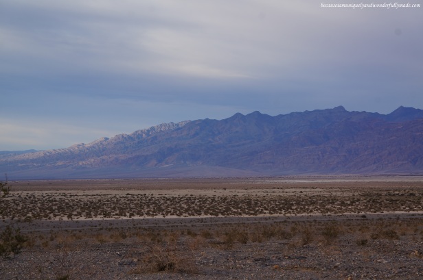
About to leave Death Valley National Park in California.View from Nadeau Trail on California Highway 190 as we were leaving Death Valley National Park.Looking ahead at Panamint Springs town as we cruise through California Highway 190 before finally leaving Death Valley National Park.Possible taken close to Town Pass.Slowly leaving Death Valley as we continue on with California Highway 190.Slowly leaving Death Valley as we continue on with California Highway 190.View from Panamint Valley Road at Death Valley National Park in California.We made a slight detour to Panamint Valley Road at Death Valley National Park in California and saw two wild coyotes roaming. They were walking just inches away from our car! We returned to California Highway 190 later to proceed to Bakersfield for the night.Death Valley slowly fading in the background as we drove higher to the mountains via California Highway 190 aiming for Bakersfield.Death Valley slowly fading in the background as we drove higher to the mountains via California Highway 190 aiming for Bakersfield.
The beautiful sunset as we headed out of Death Valley National Park.
The beautiful sunset as we headed out of Death Valley National Park.
The beautiful sunset as we headed out of Death Valley National Park.
Our first glimpse of California sunset.A beautiful palette of sunset colors as we headed out of Death Valley National Park and proceeded to Bakersfield, California to spend the night at.A beautiful palette of sunset colors as we headed out of Death Valley National Park and proceeded to Bakersfield, California to spend the night at.A beautiful palette of sunset colors as we headed out of Death Valley National Park and proceeded to Bakersfield, California to spend the night at.Our cat, Sakura Rain, enjoying her first morning in the state of California in the city of Bakersfield.
We would probably do a similar road trip from Las Vegas out towards Califronia and turning around back over Nevada someday. Death valley would definitely be a stop on that journey!
You visited one of my favorite places to shoot! And the photo at the Visitor Ctr. shows you escaped the normally hot temps. of high summer. You have to return and do some canyon hiking!
We actually visited in winter! We hope to return one day and so a little hiking although I cannot imagine doing it in summer. That would be a challenge. :)


What kind of car did you drive through Death Valley?
An Evo!
We would probably do a similar road trip from Las Vegas out towards Califronia and turning around back over Nevada someday. Death valley would definitely be a stop on that journey!
Ah, sounds fun! I wish you can do it and do not forget to bring water with you.
Fine set; thanks for sharing!
Thank you! And thank you for visiting my site :)
Although posted in August, I am guessing you were there in January.
You are right, we were there in December :)
You visited one of my favorite places to shoot! And the photo at the Visitor Ctr. shows you escaped the normally hot temps. of high summer. You have to return and do some canyon hiking!
We actually visited in winter! We hope to return one day and so a little hiking although I cannot imagine doing it in summer. That would be a challenge. :)
It looks like you are having an amazing trip. There are some great photos in here, too! Keep having fun, and thanks for the follow!
Thank you for the follow as well! I hope you will find our travels fun and informative. :)